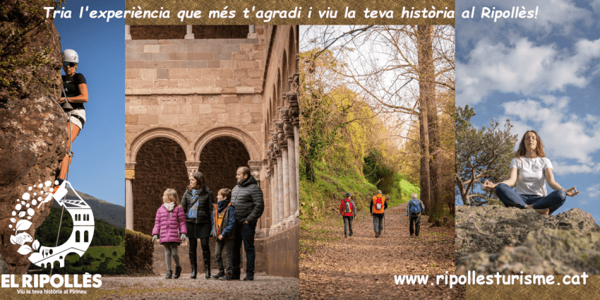
A walk along the old paths of Malgrat de Mar
Malgrat de Mar, known as the Portal del Maresme, is located between Barcelona and Girona and is surrounded by Montnegre, the Tordera river delta and the coast.
The more than five kilometers of beach that characterize the municipality are complemented by emblematic buildings and large green areas and parks that make Malgrat de Mar a suitable place to walk and enjoy a unique and diverse natural landscape.
The environment and the main economic activities that take place in Malgrat have defined the personality of Malgrat de Mar over time. Beyond the beach and the maritime tradition of the municipality that predominates in the popular imagination, Malgrat de Mar has also been, throughout its history, a town of miners and farmers.
Three signposted routes - the Tordera Delta path, the Can Palomeres Mines path and the Santa Rita path - corroborate this fact and make it possible to discover and understand, through a walk along ancient paths, the past and present of Malgrat. de Mar, as well as discovering little-known corners of the municipality.
The Tordera Delta
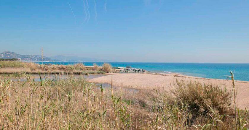
The fluvial space of the Delta del Tordera has been a determining element in the history of Malgrat de Mar. Apart from the social and productive value that it has meant for the municipality, together with its heritage and environmental values, it is the most attractive natural space to visit in the entire area.
 La Tordera is a typical Mediterranean river that rises in the Montseny massif, at the highest point of the mountain range, and after 61.5 kilometers it flows into the Mediterranean, forming the boundary between Malgrat de Mar and Blanes, which creates a soft projection that is known as Tordera's head.
It is considered the largest underground river in Europe, although in summer it almost always falls quite dry and the rest of the year it has a low flow but it allows the delta to be fed.
Due to its peculiarities, the Delta del Tordera is considered a protected natural area classified as of natural interest and is part of the Natura 2000 Network. This is characterized by forming a lagoon at the mouth closed by a bar of sand and pebbles that attracts many migratory birds that stop at this point to rest during migratory seasons, among which you can see species such as the gray heron, the squacco heron or the kingfisher.
The signposted path, which can be started in the town or next to the campsites that are on the seafront, is flat, with a slight difference in level and difficulty. During the five kilometers of the road you can visit the delta and the protected area of the dunes with native fauna and flora.
mining activity
Malgrat de Mar is characterized by having a diverse and differentiated landscape. The coastal strip is home to an extensive fertile and cultivated plain known as Pla d'en Grau, which has provided the municipality with an agricultural specialization, where among the most valued cultivated products are escarole and beans.
 This landscape contrasts with a more rugged area in the western end of the municipality where Montagut rises. This more mountainous area presents relevant geological values with mineralized sectors that gave rise, in the mid-19th century, to the exploitation of the mountain and the development of mining activity, since hematite, an iron ore, was found in this place.
Given that this mineral was discovered near Can Palomeres, the name of the farmhouse attributed personality to the mining complex that was exploited until 1914 by a French company, which gave it a great boost and created the necessary infrastructure for its exploitation, such as aerial towers that helped transport the ore to the ships. In fact, from the Malgrat de Mar promenade you can still see a large stone in the middle of the sea known as La Pilona. This was part of the artificial platform that was used for the shipment of minerals.
Currently, the area is part of the Natura 2000 Network, since it also has important values for its biodiversity linked to bat colonies.

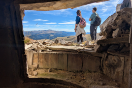
A 6 kilometer route is the route of the signposted path of Can Palomeres, which climbs up to the Cerro de Serra, 190 meters high, from where you can enjoy panoramic views of the entire municipality and the Mediterranean. This is, of the three, the most complicated route and requires a certain physical preparation. From this point, a wide path takes us to the first hills of Montnegre and takes us down towards the 7 towers. Leaving the urbanization, going down to the left of an abandoned house is the entrance to the first mine and 50 meters below this is the entrance to the second mine, which is the most spectacular, since it still preserves fragments of rock from iron on the roof. Also, next to the Rierot de Mas Joer, the well and the miners' hut are preserved.
Although the entrances to the mine are not dangerous, be careful not to bump your head on the roof.
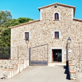
The farmhouse of Can Palomeres
 It seems that the Masía de Can Palomeres, also known as Can Plumeres, was built at a strategic point, since apart from ending up giving its name to the iron mines of Malgrat de Mar due to its proximity to them, its location on the highway, on the old royal road and taking advantage of the unevenness of the territory, suggest that this should also be a house of relevant military strategy.
Currently, it is abandoned but the remains are preserved. This farmhouse, originally from the countryside, has been documented since 1288, although, evidently, it has been reformed and enlarged over time. The elements that remain of the façade and its structure seem to correspond to the 17th or 18th century.
The route of Santa Rita
The signposted path of Santa Rita is a walk of about 2.5 kilometers that begins inside the town and that surrounds the Santa Rita hill. This is a comfortable path through the forest that surrounds the hermitage with a drop, at times, a maximum of 50 meters.
 The hermitage of Santa Rita, located on the homonymous hill, is surrounded by pine trees where you can breathe fresh air and tranquility. This is characterized by being very small, which makes it attractive, and a few years ago an annual meeting was still held.
Previously, before reaching the hermitage, the path passes through the Francesc Macià park. This is a unique park that draws attention. Giant flowers, a large pencil and a huge eraser are some of the sculptural elements that can be found. With a large area of more than 40,000 m², the park has various leisure possibilities - sports areas, rest areas, a picnic area... - which can be complemented with an excursion to the Santa Rita hermitage.
On the other hand, this itinerary can be done previously on the path to the Can Palomeras mines and link both to make a longer route.
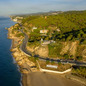
The network of paths that make up the three itineraries connects with other proposals that make it possible to extend the routes. These alternatives are the Costa del Maresme path, the La Tordera path and short and long-distance trails such as the PR-C 146 and the GR-92.

The Costa del Maresme path and the GR-92 long- distance path are proposals that run alongside the sea and make it possible to get to know this territory through a walk along the coastline.
The Tordera path, a project known by the name of Tourdera, is in the development phase, which aims to establish a greenway for cycling and hiking, linking the territory through which the Tordera runs and the Arbúcies stream, from its source to its mouth.
And, finally, the PR-C 146 short-distance footpath is a linear itinerary for the Alt Maresme that starts in Calella and goes to Malgrat de Mar.

What to do
Museu de la Pagesia de Fogars de la Selva
Fogars de la Selva (a 10.3 Km)The Museum of the Peasant of Fogars de la Selva wants us…
CG Gallery Lloret
Lloret de Mar (a 10.5 Km)CG Gallery Lloret is the first photo gallery of Cape Group. Our…
Where to eat
Pura Brasa
Pineda de Mar (a 4.2 Km)A unique gastronomic experience: Pura Brasa is a friendly and fun concept…

L'Espai Gastronomia
Tossa de Mar (a 17.7 Km)Enjoy a place where laughter, festivity, and gastronomy unfold around a large…
Where to sleep
Hotel Cleopatra Spa
Lloret de Mar (a 10.7 Km)The Hotel Cleopatra Spa is a 4 star hotel, inspired by the…
Camping Capfun Tordera-Nacions
Malgrat de Mar (a 2.9 Km)Camping Capfun Tordera-Nacions offers mobile homes and camping pitches, water sports facilities…

Hotel Acacias
Lloret de Mar (a 11.4 Km)It is a family-run establishment just 50 meters from Lloret de Mar…
L'Azure Hotel
Lloret de Mar (a 10.4 Km)L'Azure is a new hotel designed for couples and families who want…