Between the Ebro River and the Mediterranean Sea, in southern Catalonia, lies a region where popular culture beats strong all year round: Montsià. Here, festivals are not just days of celebration,…
Between sea and mountains, the penedès Less than an hour's drive from Barcelona, we find the Penedès and Alella region, a valley protected by the Montserrat mountain where we find natural…
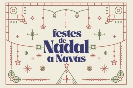
And with December come the Christmas festivities in Navàs! Get ready to experience days full of magic, excitement and tradition. Once again this year, you can enjoy the traditional "CHRISTMAS DANCE,"…
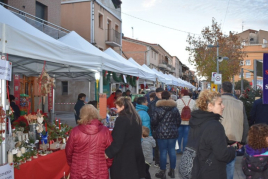
Sant Joan de Vilatorrada is preparing to once again experience the magic of its Christmas Market, an event that year after year becomes one of the most beloved moments on the local festive calendar. The…