Route of the Iberians Ausetans
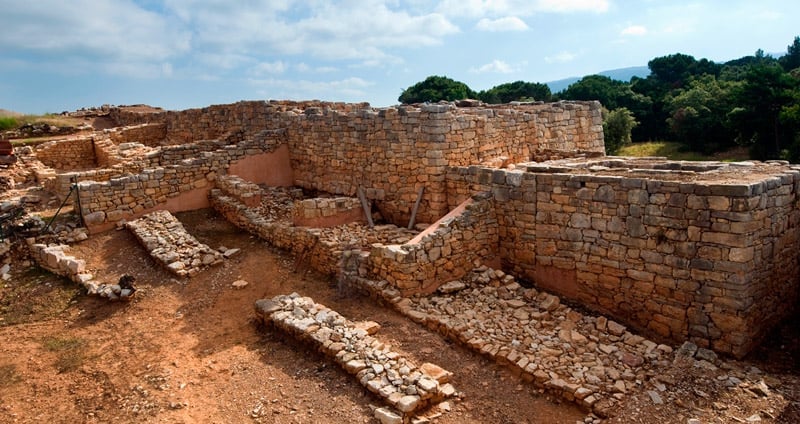
The Iberians (the name the Greeks gave to the people of the Peninsula) came to this land in the Neolithic period (5000-3000 BC) and today its origin remains unclear. Some currents consider that came from the eastern Mediterranean regions. Other reviewers from countries further north, such as Ireland, Britain and France. What is no doubt that they were the creators of the great megalithic culture on which many samples are still preserved in Spain.
In Catalonia there are 17 Iberian sites which, in turn, are divided into seven different villages. On this route we will talk about the Ausetani, who inhabited the plain of Vic and the surrounding mountain ranges. In these areas, there are three sites: The Casol of Puigcastellet, L'Esquerda and El Cerro de Montgròs.
Golden as the sun
Named for the capital of their settlement, Aura or Asua (now Vic ), his name has given way to the region where they settled, Osona. In fact, today it is not uncommon to hear "ausetano" as adjective of the inhabitants of Vic. There is evidence that the origin of the name, at least, is Indo-European and could be translated as "golden as the sun".
 They created fortified towns in strategic locations where a linked to livestock, possibly migratory, gradually was also making use of agricultural society he lived. Unlike other Iberian races, Ausetani protourbanos cores built large (for the time) that allowed them to build a strong social structure.
Defeated by the Carthaginian general Hannibal in 218 BC, they would be submitted by the Roman Empire in 195 BC, although they never stopped starring in several rebellions against the yoke of Rome.
Catalan Iberian steles
In the eighteenth century six stone steles of the period, both Ausetani deposits, as indigetes and layetanos found in Catalonia, whose dominant element lances were placed vertically.
 On the mystery of these trails, which are not part of any rite of different ethnicities íberas it is believed that its origin is abroad. The philosopher Aristotle and mentioned in his writings stating that the Iberians had a habit of sticking spears into the tombs of the warriors. The number of nozzles corresponding to the number of enemies who had killed the dead.
Little else is known about them. But after studying in detail, it is concluded that they are the memory of the passage of Iberian troops who came from Aragon. In fact, it is in this region where they have found most of these trails, on their way to the Pyrenees mountains. And it was the natural border of the Pyrenees where most of the fighting, under orders from Rome starred, to prevent the invasion of Cimbri and Teutons.
That is, the trails have confirmed what many believed. Catalan Iberian peoples that come from Aragon and were initially warrior origin.
The Casol of Puigcastellet (Folgueroles)
 Take the county road C-25 and, after surrounding Vic, stay tuned to the output to take the N-141 which leads you to the secondary road BV-5215, address Vilanova de Sau, and passing through Folgueroles.
To reach the settlement must leave Folgueroles towards Vilanova de Sau, the N-141, we find a marked path that leads to the Casol of Puigcastellet. From there comes another road to the left that leads through a slope. A little less than two kilometers we reach the Iberian ruins.
This magnificent fort is located in the Guilleries, one of the twelve natural areas of Barcelona, with an area of 8,300 hectares. Its location next to the River Ter, is privileged because from there the Ausetani controlled natural access between the plain of Vic and the lands around Girona. Ausetani were not fools, they chose the best places in Barcelona.
 Protected by a great wall, it has a central tower and eleven inside walls dividing the various rooms in a practice known as "barrier fortification" architecture.
Although there are still many questions that archaeologists are made, it is known that it was only used for over 50 years, between 250 and 200 BC, just as the Roman conquest occurred.
L'Esquerda (Roda de Ter)
There are several ways to reach either on regional roads, good roads that although they have the disadvantage of requiring a slow driving, show spectacular natural landscapes.
 Based on practical issues, we recommend you back on the road C-25 until, a few meters, the C-153, direction Olot, will lead you to Roda de Ter.
This impressive meander through the river Ter was here from the Bronze Age to the Middle Ages, a time of rest of the Romans. And it is that its cliffs were occupied from prehistory to the Middle Ages. Thanks to the ceramic remains and decoration, it is estimated that was built between the VIII-VII centuries BC
A cobbled street divided the city in half which different rooms open, many thought that they were used as warehouses and workshops. The enclosure was protected by a wall six meters width enormous rose at the end of V century BC, and accompanied by two massive towers at the entrance.
 After the abandonment of the city and its subsequent destruction due to lack of maintenance, it was rebuilt, raising and building the fortification wall whose remains are still visible in this field, but this time as medieval. Unfortunately, the area is badly damaged and could not know the reason for this neglect.
Still, the main structures of the fortification, streets and shops of the Iberian period are still preserved. Accompanied, of course, a church, a cemetery and a medieval plaza.
The route set is perfectly marked, accompanied by all the necessary information. In addition, institutions have been commissioned to rebuild part of the ruins in order to make them more visual to visitors, along with pottery, furnishings and other objects that have been rescued from various excavations.
The Turo de Montgròs (El Brull)
To go to El Brull must undo the way back to the C-25 and bordering Vic. Take the regional road C-17 towards Seva, and then switch to the BV-5303 until you see the sign that I show El Brull.
 To get to Turó of Montgròs, take the road from El Brull towards Montseny and then appear indications that direct the village. A narrow path that will lead us down into the reservoir.
As it is no wonder, this Iberian fortification is in the Montseny Natural Park, a stunning location for their views and geostrategic importance. The imposing wall was built in 300 BC with a length of 145 meters and five wide, surrounded by a great moat. Then it is reinforced with several towers and a central peripheral.
 Experts believe that the Turo de Montgròs was a fort where to shelter the population and their animals in case of danger. His subsequent fire destroyed part of the fortification in full Punic Wars in 205 BC came back to life from the V to the fourteenth century AD, at the end of the Middle Ages.
What to do
Federació Pessebres Vivents de Catalunya
Tona (a 7.5 Km)The Federation of Living Nativity Scenes of Catalonia is a non-profit cultural…
Parc d’Aventura Anigami
L’Esquirol (a 9 Km)The Anigami Adventure Park at Mas Les Comes de l'Esquirol is a…
Where to eat
La Calma, el Bellver
Tagamanent (a 7.6 Km)At the Masía Restaurante El Bellver, from 1:00 p.m. to 3:30 p.m.,…
Braseria Les Comes
L’Esquirol (a 9 Km)Located on the premises of the Anigami Adventure Park, they offer menus…
Restaurant Dachs
Les Llosses (a 24.9 Km)Restaurant Dachs offers versatile spaces for celebrations in Les Llosses, with rustic…
Where to sleep
Càmping La Vall
Taradell (a 5.1 Km)Located on the outskirts of Taradell, in a beautiful valley where a…
Casa de colònies La Traüna, Fundesplai
Fogars de Montclús (a 9.4 Km)La Traüna is located in the municipality of Fogars de Montclús, in…
Casa de colònies Can Mateu, Fundesplai
Vilanova de Sau (a 7.3 Km)Discover Can Mateu, an old farmer's house, charmingly restored to become a…

